|
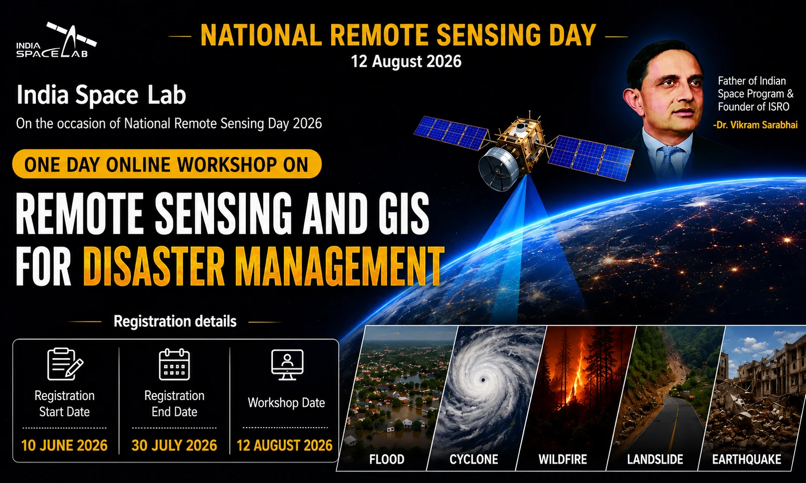
Remote sensing and geographic information systems (GIS) have become essential technologies for disaster management, environmental monitoring, agriculture, urban planning, and infrastructure development. To celebrate National Remote Sensing Day 2026, Indian Space Laboratory is organizing a one-day online workshop on “Remote Sensing , Sensing and GIS in Disaster Management”.
The workshop provides an opportunity for students, researchers, engineers, GIS professionals, government employees and technology enthusiasts to learn how to use satellite imagery , imagery and GIS techniques to predict, monitor and manage disasters such as floods, hurricanes, wildfires, landslides and earthquakes.
If you want to improve your GIS skills and get a certificate of participation, this workshop is an excellent opportunity.
Workshop Highlights
- Workshop Name: Remote Sensing and GIS for Disaster Management
- Organizer: India Space Lab
- Occasion: National Remote Sensing Day 2026
- Mode: Online
- Workshop Date: 12 August 2026
- Registration Start: 10 June 2026
- Last Date to Register: 30 July 2026
- Registration Fee: ₹270
- Certificate: E-Certificate
- Duration: One Day
What is Remote Sensing?
Remote sensing is the science of collecting information about the Earth’s surface without making direct physical contact. Instead of visiting every location manually, satellites, aircraft, and drones capture images using specialized sensors.
These images help scientists understand changes occurring on Earth’s surface over time.
Remote sensing plays a vital role in:
- Weather forecasting
- Agriculture monitoring
- Forest conservation
- Urban development
- Water resource management
- Environmental protection
- Disaster management
- Military surveillance
What is GIS?
GIS (Geographic Information System) is a computer-based system used to capture, store, analyze, visualize, and interpret geographical data.
GIS combines satellite images with maps, demographic information, environmental data, and infrastructure details to help decision-makers solve real-world problems.
Today, GIS is widely used in:
- Smart Cities
- Government Planning
- Disaster Response
- Transportation
- Healthcare
- Utilities
- Mining
- Agriculture
- Civil Engineering
- Urban Planning
Why Remote Sensing and GIS Are Important for Disaster Management
Natural disasters often strike with little warning. Remote sensing and GIS enable authorities to monitor, predict, and respond more effectively.
These technologies support:
|
Flood Monitoring |
Cyclone Tracking | Wildfire Detection | Landslide Risk Assessment | Earthquake Damage Assessment |
| Satellite imagery identifies flooded regions in real time, helping authorities evacuate affected communities and distribute relief efficiently. | Meteorological satellites monitor cyclone formation, movement, and intensity, enabling early warnings that save lives. | Thermal sensors detect forest fires before they spread, allowing rapid emergency response. | GIS analyzes terrain, rainfall, soil conditions, and slope stability to identify landslide-prone areas. | Post-earthquake satellite imagery helps emergency teams assess structural damage, blocked roads, and affected populations. |
Topics Covered During the Workshop
Participants can expect sessions on:
- Introduction to Remote Sensing
- Basics of GIS
- Types of Satellite Sensors
- Satellite Image Interpretation
- Disaster Mapping
- Flood Analysis
- Cyclone Monitoring
- Forest Fire Detection
- Landslide Mapping
- Earthquake Damage Assessment
- GIS Applications
- Remote Sensing Software
- Real-world Case Studies
- Future of Geospatial Technologies
Who Can Attend?
The workshop is suitable for:
- Engineering Students
- Diploma Students
- Polytechnic Students
- B.Sc. Students
- M.Sc. Students
- Geography Students
- Civil Engineering Students
- Environmental Science Students
- Architecture Students
- GIS Professionals
- Researchers
- Government Employees
- Faculty Members
- Working Professionals
- Anyone interested in geospatial technology
No advanced knowledge of GIS is required for beginners.
Eligibility Criteria
There are no strict eligibility requirements. Anyone interested in remote sensing, GIS, or disaster management can participate.
Registration Fee
The registration fee is ₹270.
The fee generally covers:
- Live online workshop
- Learning materials
- Expert sessions
- Participation certificate
- Access to presentations (subject to organizer policy)
Certificate
Participants who successfully attend the workshop will receive an E-Certificate from India Space Lab, which can strengthen resumes, LinkedIn profiles, internship applications, and academic portfolios.
Benefits of Joining This Workshop
Participating in the workshop offers several advantages:
- Learn from experts in Remote Sensing and GIS
- Understand real-world disaster management applications
- Gain practical exposure to geospatial technologies
- Enhance technical knowledge
- Improve employability
- Build a stronger resume
- Earn an industry-recognized participation certificate
- Network with students and professionals across India
- Prepare for careers in GIS, satellite technology, urban planning, and environmental sciences
Career Opportunities After Learning GIS and Remote Sensing
Knowledge of GIS and Remote Sensing can open doors to careers such as:
- GIS Analyst
- Remote Sensing Specialist
- Geospatial Engineer
- Survey Engineer
- Environmental Consultant
- Disaster Management Officer
- Urban Planner
- Cartographer
- Drone Data Analyst
- Satellite Image Analyst
- Research Associate
- GIS Developer
- Climate Change Researcher
- Government GIS Expert
Many government organizations, private companies, research institutes, and international agencies recruit professionals with these skills.
Why Students Should Attend
Students can gain:
- Exposure to emerging technologies
- Industry-oriented learning
- Certificate for resume building
- Practical understanding of satellite applications
- Networking opportunities
- Better internship prospects
- Preparation for higher studies and research
How to Register
Follow these steps:
- Visit the official India Space Lab workshop registration page.
- Complete the online registration form.
- Pay the registration fee.
- Submit your details.
- Receive confirmation via email.
- Join the online workshop on the scheduled date using the meeting link provided by the organizer.
1 . Click Here To Apply Now
| 2. | Guidlines / Circular | Guidlines / Circular Click Here. |
| 3 | Download Workshop Flyer | Click Here |
| 4 | Registration Start Date | 10-06-2026 |
| 5 | Registration End Date | 30-07-2026 till 11:55 PM |
| 6 | Workshop Date | 12-08-2026 |
| 7 | Mode of Workshop | Online |
| 8 | Download Your Certificate | Click Here |
Note: We are also on WhatsApp, LinkedIn, Google News, and YouTube. To get the latest news updates, subscribe to our Channels: WhatsApp—Click Here, Google News—Click Here, YouTube—Click Here, LinkedIn—Click Here, Telegram – Click Here, Twitter – Click Here, Facebook – Click Here
Frequently Asked Questions (FAQs)
Yes, the workshop will be conducted online.
The registration fee is ₹270.
The workshop will be held on 12 August 2026.
The last date for registration is 30 July 2026.
Yes, eligible participants will receive an E-Certificate after completing the workshop.
Students, researchers, professionals, faculty members, and anyone interested in Remote Sensing and GIS.
No. Beginners can also participate.
These technologies are widely used in environmental management, disaster response, urban planning, agriculture, defense, infrastructure, and scientific research, making them valuable skills for academic and professional growth. |